
“We should be smooth sailing today. The jet stream is at our back, making our flight arrive a half hour early”
“The jet stream is located across the southern U.S. This will bring us very cold temperatures for the rest of the week”
Hop on a flight or turn on your favorite local news channel and you will probably hear something about the jet stream every once in a while. But what does it mean?
The jet stream is not something which brings us good or bad news randomly. In fact, this atmospheric phenomenon has been studied by meteorologists since the 1800s (mostly due to the Krakatoa Volcano explosion http://en.wikipedia.org/wiki/Jet_stream#Discovery). Picture the jet stream as a current of air that circles the upper levels in the Earth’s atmosphere, between 30,000 to 40,000 feet (300 to 200 mb in the meteorological community). It is located at the tropopause, which is the region that splits the troposphere (the lowest part of the atmosphere, where live) and the stratosphere (the next layer up, temperatures warm with height). In general, the jet stream flows in an easterly direction around the globe.

A vertical cross section of the atmosphere, depicting where the jet streams are typically found. Courtesy of NOAA
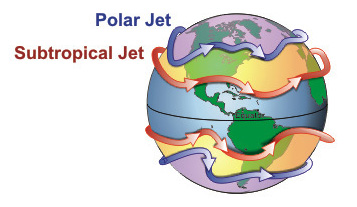
The northern hemisphere has not one, but two jet streams, which are a result of vertical circulations within the atmosphere and the Earth’s rotation. The subtropical jet typically circles the globe around 30° (north & south latitude), while the polar jet flows at 50 – 60° (north & south latitude). These two jet streams separate three “armies” of air (tropical, subtropical and polar) and feed off temperature gradients between the three. Basically, the stronger the temperature gradient, the more powerful the jet stream can be. In fact, winds in the polar jet (the strongest), can reach speeds over 200 mph. This is why airlines will take advantage of it whenever possible !!
Now, these jet steams do not just stay in one place, they meander and shift based on the largest temperature gradient and the seasons. For example, when the polar jet shifts south, frigid air typically locked up over the arctic, is allowed to funnel further south than normal. If the jet ridges north, warm air is allowed to flow north from the subtropical regions. These are the reasons why meteorologists tend to cite jet streams rather often in forecasts.
Meteorologists also use the jet stream to figure out storm development and track. When the jet stream buckles or kinks up, basically diverting from the typical easterly direction, storm systems can form. The areas of low pressure then propagate downstream along the jet stream, just like airlines do when travelling west to east. This is why the jet stream is so crucial to forecasts and why meteorologists monitor it so closely.


